

-
What is the Geovisor?

The Geovisor is an advanced tool of the Wayúu Information System. It centralizes and visualizes data on the Wayúu indigenous people, integrating information from various national and regional government entities.
-
How does it work?
This geospatial tool allows users to observe and analyze crucial aspects of Wayúu life in detail. It brings together information in one place; the geoviewer offers a clear and comprehensive overview of the conditions and needs of the Wayúu indigenous people.
-
What is it for?
The geovisor helps decision-makers formulate public policies and programs that are more effective and tailored to the Wayúu reality. The tool promotes more coordinated and efficient resource management, respecting the cultural identity of the Wayúu indigenous people and supporting their development and well-being..
How do I use it?
Streetview
With up-to-date and accurate data, entities can collaborate more effectively to address identified issues and guarantee the fundamental rights of the community, thereby improving their quality of life and contributing to a more integrated and coherent response to their needs.
We answer your questions
-
In the context of maps, a layer is a set of geographic data that is superimposed on a base map. Each layer contains information on a specific topic, such as the location of water sources, regional roads, roads under construction, and health care centers. By turning these layers on or off, you can view different types of information.
-
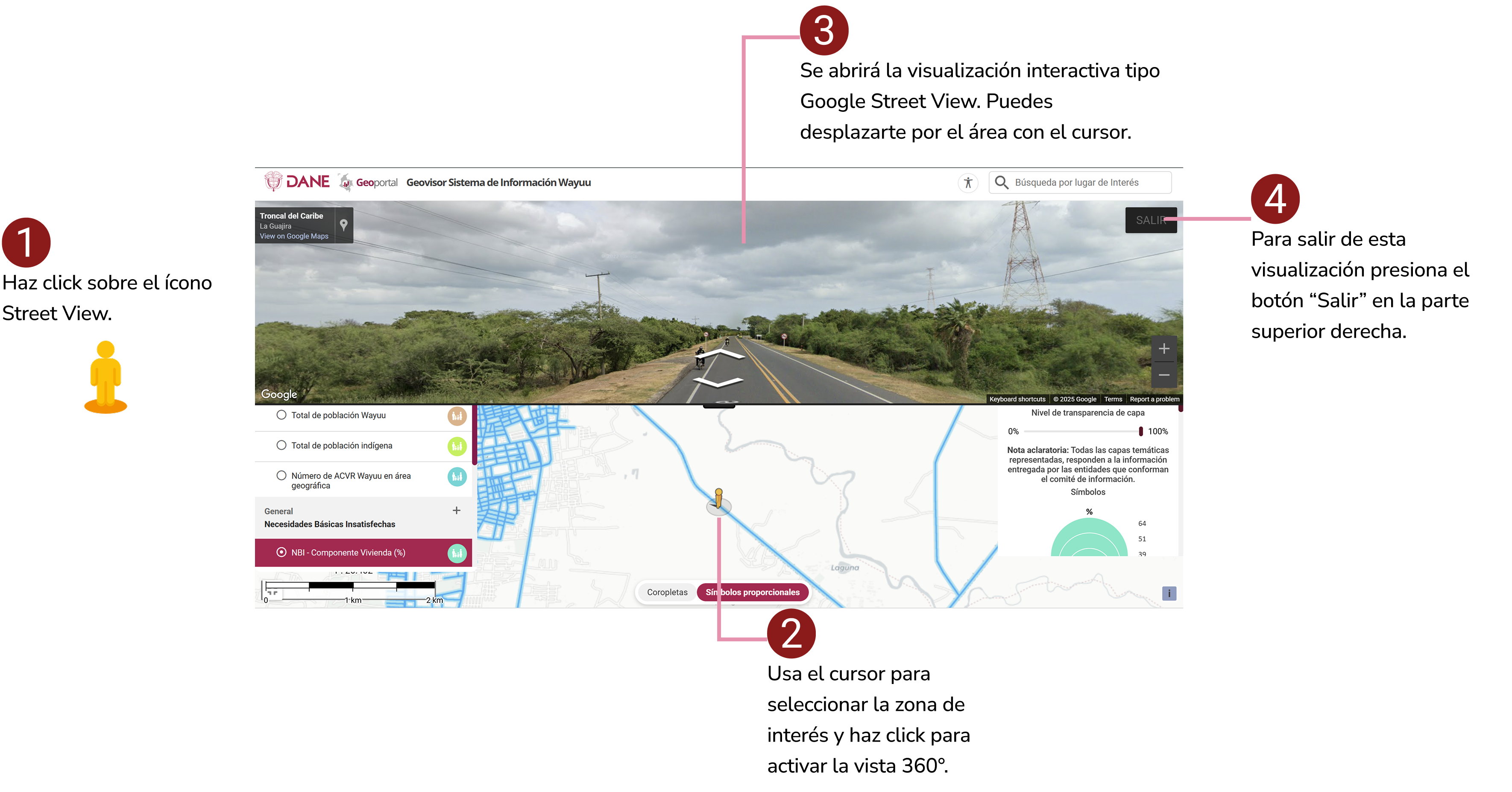
It is a feature that allows you to explore a location on the map with 360-degree panoramic images at street level. By selecting a point on the map where the feature is available, you can navigate virtually and get a realistic view of the surroundings.
-
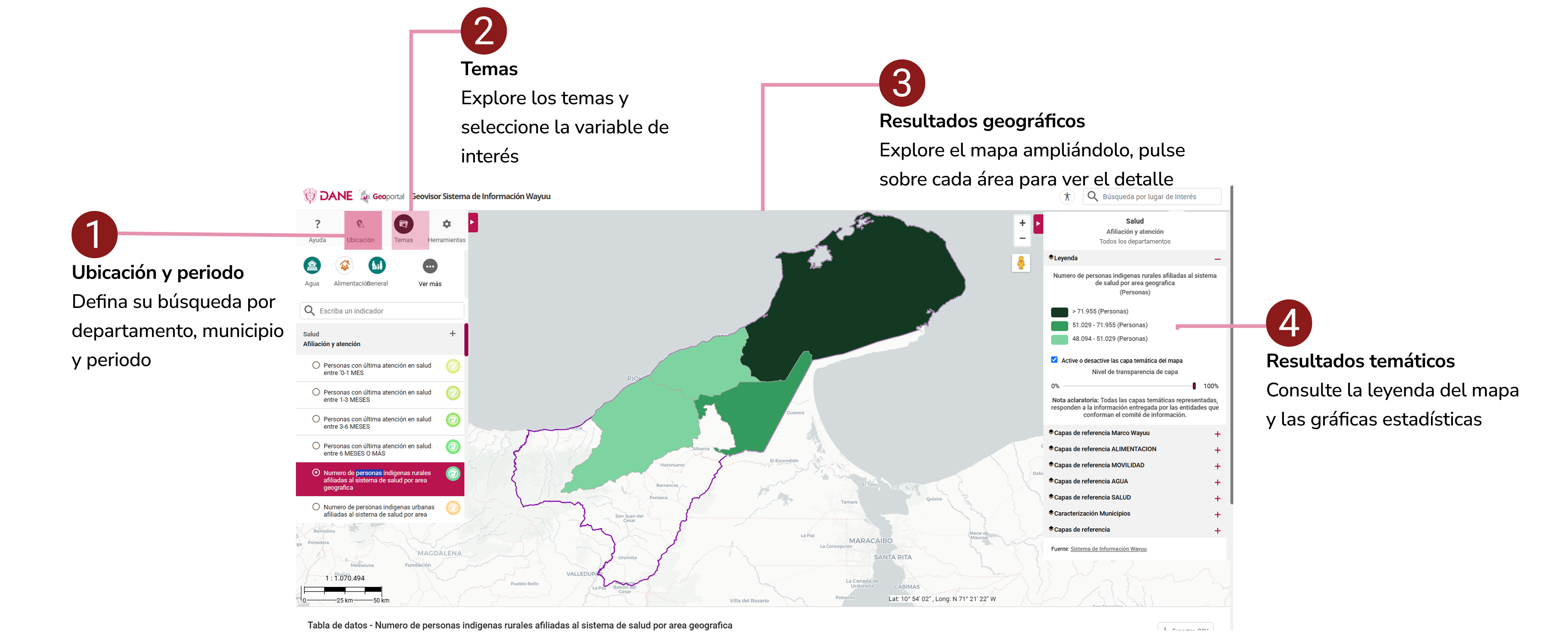
The 'Location' tool allows users to filter and view data according to geographical level, such as department or municipality. Its usefulness lies in the fact that it facilitates the exploration of information in a specific way, allowing users to analyze a specific area of interest in the Wayúu territory and view only the data relevant to that area.
-
This tool allows users to explore data on the Wayúu territory organized into key thematic areas such as Water, Food, General, Mobility, and Health. Its usefulness lies in the fact that it facilitates the search for specific information, allowing for faster and more focused analysis in different dimensions, without having to navigate through all the data in a disorganized manner.
-
They are a method of coloring a map that helps you quickly understand the data. It's like painting a map by region, where the intensity of the color represents the intensity of a piece of data. For example, on a map showing the prevalence of a disease, a light color could mean a low number of cases, while a dark or intense color would indicate a high number of cases.
-
They are another type of symbolism that uses the size of a symbol (such as a circle) to represent a value. If the circle is large, it indicates a high value (for example, a large number of cases of malnutrition); if the circle is small, the value is low.
-
¿Qué es el Geovisor?
El Geovisor es una herramienta del Sistema de Información Wayúu que permite consultar información del territorio a través de mapas interactivos. Integra datos de distintas entidades, tanto nacionales como territoriales.
-
¿Cómo funciona?
El geovisor reúne información del territorio en un solo lugar y permite consultarla a través de mapas interactivos.
-
¿Para qué sirve?
El geovisor permite consultar información del territorio de manera organizada y visual, facilitando su lectura y comprensión.
Resolvemos sus dudas
-
En el contexto de los mapas, una capa es un conjunto de datos geográficos que se superpone a un mapa base. Cada capa contiene información sobre un tema específico, como la ubicación de las fuentes de agua, vías regionales, vías intervenidas, centros de atención de salud. Al activar o desactivar estas capas, se puede visualizar diferentes tipos de información.
-
Es una función que permite explorar una ubicación en el mapa con imágenes panorámicas de 360 grados a nivel de calle. Al seleccionar un punto en el mapa donde la función esté disponible, se puede navegar de manera virtual y tener una vista realista del entorno.
-
La herramienta de 'Ubicación' permite a los usuarios filtrar y visualizar datos según el nivel geográfico, como el departamento o el municipio. Su utilidad radica en que facilita la exploración de la información de manera específica, permitiendo analizar un área de interés concreta en el territorio Wayúu y ver solo los datos relevantes para esa zona.
-
Esta herramienta permite al usuario explorar los datos del territorio Wayúu organizados en ejes temáticos clave como Agua, Alimentación, General, Movilidad y Salud. Su utilidad radica en que facilita la búsqueda de información específica, permitiendo un análisis más rápido y enfocado en distintas dimensiones, sin tener que navegar por todos los datos de forma desorganizada.
-
Son un método para colorear un mapa que ayuda a entender rápidamente los datos. Es como pintar un mapa por regiones, donde la intensidad del color representa la intensidad de un dato. Por ejemplo, en un mapa de la prevalencia de una enfermedad, un color claro podría significar un bajo número de casos, mientras que un color oscuro o intenso indicaría un alto número de casos.
-
Son otro tipo de simbología que usa el tamaño de un símbolo (como un círculo) para representar un valor. Si el círculo es grande, indica un valor alto (por ejemplo, un gran número de casos de desnutrición); si el círculo es pequeño, el valor es bajo.
-
¿Kaasa chii geovisorka?
Chii geovisor shia wanee ayataaya mamaasat alatiria suchikuu wayuu okootchiitsü otta shiiraka sumu'in tu süchikuumajatka tu sumainpaaka wayuu, suntirerüin putchi sulu'ujijat miichi laulaapia maaka Mmaaka jee o'umañu.
-
¿Jamusü shiatayaa?
Tu ayataayaka eraajiakat apusüü e'erajaa otta shiyaawatüin jamüin sukuaipa wayuu shiipialu. Sukotchajüin tu akujalakat sulu'u wanesia sukuipa; chi geovisor münakai niatüin wane anajiou anas je kolotusü alain summain Wayuu je kasa cho'ujaka namüin.
-
¿Kaasa kapulajaatka?
Chii erajiakai naapüin naamuin apülikat suküaipai tu akuujaaka sukuaipa ayataawa Mmapuna otta naayataainka anainjatu wanainjatu sumaa naakuwaipa wayuu. Tü ayataaya sukumajuin sukuaipaa lootuin jee ana'in tu antaakat, kajuutusü tu akuuwaipaaka sa'u sumaiinpaa wayuu jee akalinjuruuin sünaiin sajaapulain e'in anaa.
¿Jamerü saapaya?
Streetview
Süka tü akujakat pansaakat je ayatüin, tü Laülaapiakaluirüa eesü süpüla sukalinjain anatera tü kasa muliakat atuma je shirajüin sünain lotüin sukuaipa wane kasa sümuin tü wayuukaluirüa, süpüla sünatain tü kataakat o'u je neeittüin sünain tu aküjala süchiki tu cho'ujakat amüñu.
Wakujeerü tuu nnojotka piyawatuin a'u
-
yaa so'u tu shiipakat Mmakat, wanee shiipoujana shia wanee waima süchikümajatuu tü saapünajatka sütchin Mmaa. Waneewai shüpoujana kaluusü süchikumajat wanuwai jalaiin eiin saamajulee wuin, woopuu ainjunuinjatu, Michii eerajaleinjatu, e'intanuinjatu jee shishawaleenuiin tuu shiipoujanaka, esu supula shiirüünnuin naajatuin wanne süüchikuu.
-
Shia wanee sutchin meekeeraa süchiruwa e'ere shiiakua suupaa tu Mmakat jee 360 saaiira anoipa. Suneekunaapa ee'injatu'in suutu'in tu ainnajatka, eerünnajatu wattaje shimain tu eeka süünaa.
-
tüü ayataayakat suna'in tu ee'in tuu anashikaat napula naa wayuukana naalatiruin otta neiraka'in sumuin suuchiku tu sumaaka tu mmaapaka, maaka sain tepartamentoko jee municipioka. Yaasuja supulain apüin suchajanuin tu suchikumajaatka shiain, apüin shiawatunuin e'ere keire'in ainñu tu choujaakaa sulu'usuma'in wayuu neerüin wanesia tu suchikuumajatka jainjaiin sulu'u tu Mmaapakat
-
ayataayakat tüü apüsü naamüin naa wayuukana suchikumajatu Noumain wayuu akumajushi suna'in naatawalin supula tu ashajawaka shikuu wuin, ekuulu'u, süpushua, awaarairat, otta anaa. Tü sukuaipakat apusü achajawa suchiiku shimain, supula ananajaa saa muin kaalapüin otta suntunuin eepünaa suuchiku nnoojoluin anaiin sukuaipa.
-
shia sukuaipa akanajaa wanee shiipa Mmaa akalinjasüü sunaiin mootso shiyaawatia tu achikuukat, müüsuka sa'in ashajawaa wanee shiakuwa Mmaa mootsoowain, e'ere emeetulüiin suukanajia shiiawasw e'ere wanee süchikuumajat. Maaka sain wanee akanajia paisi akuujasu suchiiku wüunapünain shiawajia akuaipa. sumainrü ipuunaiin shiyawajia akuaipakaa.
-
Shia supushi shiawase'e sajaapuin maaka sain wanee (kooyosu) e'iyatia wanee sujuutu mioulee, tu kooyoosuka, akujasu suchiku sujuutu ipuunaale (maaka sain, shiawajia jeeraasü jamushirü), moosolee shii kootushikai) mmalu'usu sujutuu.